Delamerian Base Metals Project
The Delamerian project is located in the Delamerian Orogen in western New South Wales. The project consists of an area of 1,936 square kilometres at the northern end of the Koonenberry Belt, 60 kilometres east of Tibooburra and an area of 2,344 square kilometres in the Loch Lilly-Kars Belt, 55 kilometres southeast of Broken Hill.
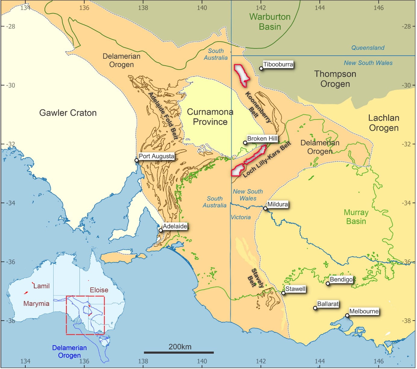
Delamerian Orogen and Project Locations
The Delamerian Orogen comprises Late Neoproterozoic to Ordovician rock sequences stretching from eastern South Australia, through western New South Wales and Victoria to western Tasmania. It encompasses the remnants of an accretionary craton margin that hosts Late Neoproterozoic to Cambrian rift related mafic magmatism and Middle Cambrian to Early Ordovician felsic magmatism. The mineral potential of the orogen is well recognised in the areas where it outcrops – the Adelaide Fold Belt in South Australia, the Stavely Belt in Victoria and the Mount Read Volcanics in Tasmania – however large portions of the orogen are covered by younger basins, such as the Murray Basin. This has deterred exploration historically and has limited the understanding of the orogen’s full mineral potential.
The northern tenement area covers approximately 80 kilometres of strike of a covered extension of Late Neoproterozoic Kara Formation which hosts primitive mafic igneous intrusives of the Mt Arrowsmith Volcanics. The presence of extensive mafic/ultramafic sill complexes in craton margin sediments is considered analogous to settings that host large Ni-Cu -PGE sulphide systems globally (e.g. Albany Fraser Belt in Western Australia and the Circum-Superior Belt in Canada).
The southern tenement area covers approximately 150 kilometres of strike of the Loch Lilly-Kars Belt under the shallowing margins of the Murray Basin. The application has secured almost the entire Loch Lilly-Kars Belt. Based on geophysical and drill hole data, the belt is interpreted as consisting of geological sequences formed in a back-arc basin setting. These settings are known to host Volcanogenic Massive Sulphide (VMS) deposits. There is also evidence of felsic high-level subvolcanic intrusions, often associated with magmatic related copper deposits, and mafic intrusive complexes providing Ni-Cu-PGE potential. A series of major belt-scale faults are observable that would act as major fluid flow conduits during both early extensions and later deformation of the belt.
Peake and Denison Copper Project
The Peake and Denison project is located 750km NNW of Adelaide along the NE margin of the Gawler Craton. The project covers approximately 2,500 square kilometres of the Peake and Denison Inlier within 4 granted exploration licenses. AIC Mines is targeting Iron-Oxide Copper-Gold style mineralisation. AIC Mines acquired the project as part of the takeover of Demetallica Limited in December 2022.
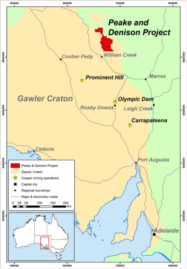
Peake and Denison Project location map
There are strong similarities between the Peake and Denison Inlier and the Iron-Oxide Copper-Gold (IOCG) mineral systems around Cloncurry. Visible copper mineralisation has been intersected at the Mawson and Wills targets and has strengthened the validity of the exploration model targeting IOCG mineral systems in the Peake and Denison Inlier.
Inlier basement rocks at Peake and Denison proffer excellent potential for IOCG mineralisation, based on data from limited historical drilling. The data show intense sodic-calcic-iron alteration developed at broadly the same age (1520-1470Ma) as mineralogical assemblages that occur as alteration with copper in the Cloncurry region. Additionally, granite intrusives at Peake and Denison at circa 1530Ma also correlate with the same age range (1547-1493Ma) as the Williams – Naraku granites around Cloncurry that are also linked to copper-gold mineralisation.
A maiden drilling program conducted in 2022 tested three magnetic anomalies: Wentworth; Mawson; and Wills each with a single drill hole. Drilling at the Mawson and Wills targets intersected visible copper mineralisation.
Pyramid Gold Project
The Pyramid tenement group is located southeast of Charters Towers in north Queensland. The project, covering 150 square kilometres, embraces two main areas prospective for gold, being the West Pyramid Range and East Pyramid Range. AIC Mines acquired the project as part of the takeover of Demetallica Limited in December 2022.
West Pyramid Range offers potential to expand the gold mineralisation footprint defined through historic work, especially along an 8 kilometre section of the Gettysberg Fault corridor. The East Pyramid Range offers potential for Intrusion Related Gold Systems (IRGS), similar in style to other well-known gold deposits in the district such as Mount Leyshon (+3.5Moz) and Mount Wright (+1Moz).
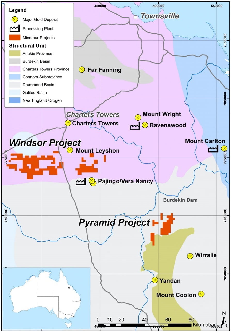
Pyramid Project location map
Windsor Base Metals Project
The Windsor tenements are located 60 kilometres south of Charters Towers in north Queensland. Covering 629 square kilometres, the tenements offer discovery potential for high-grade VMS style mines, such as the nearby Thalanga, Highway-Reward, Waterloo and Liontown deposits. AIC Mines acquired the project as part of the takeover of Demetallica Limited in December 2022.
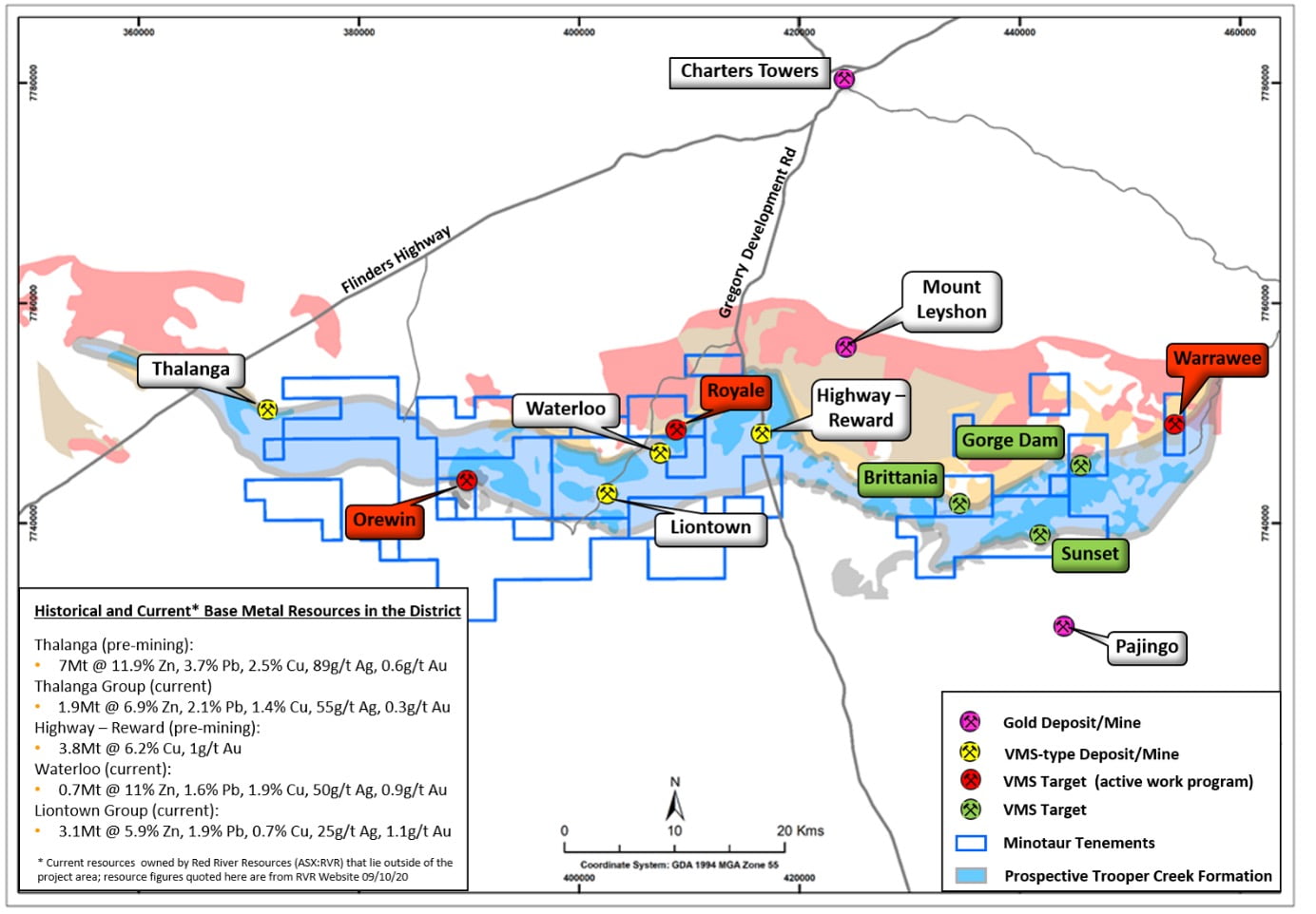
Windsor Project location map
Stratigraphic horizons encapsulating those deposits are interpreted to continue through the Windsor project area. Past exploration has been inhibited by the highly conductive nature of the cover sequence and previous drilling is sparse and shallow; thus most of the project area is relatively lightly explored.